Nicolai had just spent his PhD years discovering that portolan charts — those gorgeous, wind-rose-covered coastline maps that suddenly appeared in Mediterranean ports in the second half of the 13th century — were geometrically too accurate to have been made the way everyone assumed. Something else was going on. Twelve years on, we might have an answer.
Tome Marelić, an assistant professor of geography at the University of Zadar in Croatia (and the current vice chair of the Working Group on the History of Cartography within the International Cartographic Association), has spent years doing exactly the step-by-step thinking Nicolai prescribed in 2014. Read together, his scientific articles amount to the most detailed forensic examination portolan charts have ever received. And the story they tell is more satisfying than even the more out-there theories (including “aliens did it”).
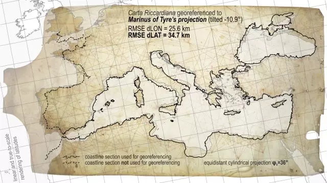
Dated to the latter part of the 13th century, the anonymous Carte Pisane is the oldest surviving portolan chart. However, its high degree of accuracy suggests that it is not the beginning, but the continuation of a long tradition. So where did that knowledge come from? ( ity origin of spatial data underlying portolan charts: how Pietro Vesconte might have assembled the Carta Riccardiana utilising maps in Marinus of Tyre’s projection, 2026) First, a quick refresher.
A portolan chart is a nautical chart of the Mediterranean, western European, and northwest African coasts, criss-crossed with dense color-coded web-like networks often called “rhumb lines,” dotted with harbor names written perpendicular to the coast (so you had to keep spinning the chart to read it). The charts are calibrated with little beaded scale bars marking off distances in _miglia_, or so-called _portolan miles_ whose roots remained enigmatic for decades until Marelić’s recently proposed explanation. (A Portolan mile is a bit shorter than a modern statute mile.) The oldest surviving example, the anonymous _Carte Pisane_, appeared in Italy around 1270. Geometrically speaking, it looks like a finished product.
There’s no awkward teenage phase of European cartography preceding it — no 13th-century equivalent of a flip phone before the smartphone. It just arrives, fully formed, with Mediterranean coastlines accurate enough to _almost_ look like a map from today. The traditional explanation is romantic and, at first glance, plausible: Generations of sailors recorded their compass bearings and estimated distances in logbooks, and cartographers eventually compiled all that dead-reckoning data into a single chart.
The trouble, as Nicolai discovered first, is that the numbers don’t work. Simulate a medieval ship captain’s best-effort compass-and-guesswork navigation, average enough of those readings together, and you get a chart ten times less accurate than the actual portolan chart. This is where Marelić comes in.
Extract — continue reading at the source.