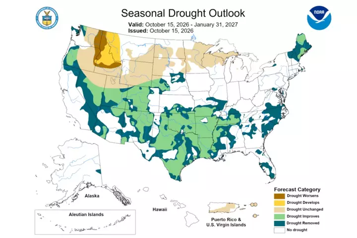
Drought conditions could develop or worsen for parts of the northwestern U.S. in the coming months, as meteorologists expect El Niño to help shape the winter season. The National Oceanic and Atmospheric Administration (NOAA) issued its winter outlook this week. In it, the agency outlined how the climate pattern could influence temperature and rainfall during winter and said drought conditions are favored to develop or worsen across parts of the northern Rockies.
El Niño is a naturally recurring climate pattern associated with warmer waters in the Pacific that can influence temperatures and rainfall worldwide. In the U.S., typical El Niño effects can include stormier weather across southern regions, drier conditions in some northern areas and changes in hurricane activity. The Climate Prediction Center said earlier this month that El Niño had continued to strengthen, with chances remaining high for a “strong-to-very strong” event through January to March 2027.
The agency also said chances were high for “a historic event that would exceed the strength of previous El Niño events dating back to 1950.” Northeastern Oregon and eastern Washington, as well as parts of the northern Rockies, would likely see drought develop or worsen through January, according to NOAA’s drought outlook. On the other hand, conditions are forecast to improve or end in the Southwest, Southern Great Plains, Southeast and parts of the East Coast. The outlook also mapped the parts of the country most likely to experience above- or below-average temperatures and precipitation during the winter months.
They showed higher chances of above-normal precipitation across much of the West and East Coasts, along the southern tier of the country, and into the Central Plains. Drier-than-average conditions appeared more likely in Michigan and northeastern Wisconsin, as well as parts of Washington, Idaho, Montana, and North Dakota. Meanwhile, the outlooks suggested above-normal temperatures are more likely across the northern tier of the country and much of Alaska.
Above-normal temperatures were also favored across portions of California, the central U.S., the Ohio Valley and the Mid-Atlantic, although generally with lower probabilities. Near-normal temperatures appeared likely along much of the Gulf Coast, including Florida. NOAA meteorologist Scott Handel previously told Newsweek that the temperature and precipitation outlooks indicate the probability of seasonal temperatures and precipitation being above, near or below normal, rather than forecasting specific values or individual weather events.
Extract — continue reading at the source.