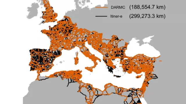
A recent study now links those two well-worn proverbs by suggesting that the footprint of Roman road infrastructure was 59% larger than previously thought. The revelation isn’t just quantitative — a network with a finer mesh might change what we think life was like across Rome’s vast domain. The findings come from the research team behind Itiner-e, a project that published a digital atlas of the Empire in _Nature’s Scientific Data_ in late 2025.
They mapped about 186,000 miles (just under 300,000 km) of roads across Rome at its greatest extent. This was in the 2nd century AD, when the Empire sprawled from Hadrian’s Wall in northern England to the western shores of the Persian Gulf. The previous reference catalog, the Digital Atlas of Roman and Medieval Civilizations (DARMC, now known as Mapping Past Societies), tallied around 117,100 miles (188,500 km) — meaning the new figure is 59% longer than the earlier total. _Roman roads transported more than people and goods, they also moved ideas and religions to faraway places, as shown by this altar to the Persian god Mithras, discovered in 2010 in Scotland, at the very northern edge of Rome’s road network. (__Credit__: National Museums Scotland)_ To be clear, the researchers have not discovered that Rome had a secret “lost” highway system.
They didn’t discover a massive imperial ring road or dig up a legionary engineering project concealed for two millennia. The explanation is less Indiana Jones, more Beancounter Bob. Earlier compilations of the Roman road network tended to privilege great, well-documented routes like the Via Appia (Rome to Brindisi) or the Via Egnatia (from Albania’s coast to Byzantium).
The connective tissue between those major roads — the first- and last-mile bits that actually got produce to market, villagers to town, soldiers to frontiers, and tax collectors to your door — received less attention. What the Itiner-e researchers did was create, from a wide and scattered body of evidence, a much fuller and more precise record of roads that definitely existed, and also ones that researchers suspect existed, with varying degrees of confidence. Itiner-e’s final result makes the imbalance plain.
Of its roughly 186,000 miles of roads, only about 34.6% are classified as main arteries. The remaining two-thirds are secondary routes or smaller. Roman roads were much like ours: a mixture of grand highways, regional roads, and rural lanes.
While the major thoroughfares get all the press, the smaller ones probably played an important part in everyday work. As an international project with contributors from the universities of Barcelona and Aarhus, among others, Itiner-e built its Roman road atlas (the expanded version) in three painstaking phases. Four times a year, the Big Think print magazine shows up at your door.
Extract — continue reading at the source.