All websites claim that the origin of this obelisk is both unknown and mysterious. However, adding a single piece of information solves the mystery entirely. Extract from Vandermaelen’s maps (1846–1854) showing Bouillon Castle – which no longer exists – and the ‘pyramid’.
Cartes de Vandermaelen (1846-1854) Extract from Vandermaelen’s maps (1846–1854) showing Bouillon Castle – which no longer exists – and the ‘pyramid’. Cartes de Vandermaelen (1846-1854) Verlée is a small hamlet located an hour and a quarter's drive south-east of Brussels. Apart from a few limestone farmhouses, the village itself is small and of little interest.
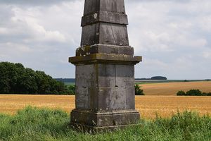
However, when leaving Verlée via the road to Petit Avin, visitors are surprised to discover a stone obelisk in the middle of the countryside. It stands on a ridge alongside the road. There are no nearby buildings and no signs explaining its presence.
There is no inscription on it, and only the carved garlands at the top allow it to be dated to the early 19th century, the Empire period. An internet search only deepens the mystery: no website offers a satisfactory explanation for the origin of this monument, which has been nicknamed 'Belgium's only pyramid' … because they all overlook a crucial piece of information. A popular theory suggests that the monument was a topographical landmark that helped the French colonel Jean-Joseph Tranchot carry out a triangulation survey of the Rhine region and a small part of northern Belgium between 1801 and 1813.
While this theory may seem plausible — the monument is highly visible on a hilltop, the other surviving landmarks are obelisks and the historical period matches the carved decoration — it is incorrect. Tranchot's maps have been preserved and simply do not cover this region. Therefore, no other hypothesis seems capable of explaining the existence of this monument, except that no website mentions an important detail.
Looking at historical maps of the area reveals that a castle, now lost, stood 750 metres north-north-east of the monument. This castle is known as the "Château de Bouillon" and should not be confused with the famous castle of the same name in the south of the country. Rue Haveligeoule, which leads to the obelisk, lies perfectly on the axis between the two sites, and one side of the obelisk is precisely aligned with this axis.
Extract — continue reading at the source.

/https://tf-cmsv2-smithsonianmag-media.s3.amazonaws.com/filer_public/6c/cd/6ccd5e01-e02d-493d-afe2-b75b33883c4e/smithsonian_feature_images_22.png)
/https://tf-cmsv2-smithsonianmag-media.s3.amazonaws.com/filer_public/cb/f0/cbf09863-7b51-4a6e-9146-18afe0ba8b81/tomb2.png)