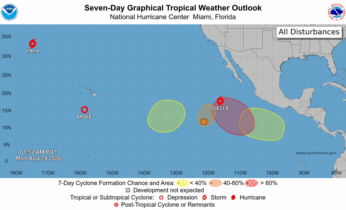
As Tropical Storm Iselle churns across the eastern Pacific, forecasters are watching a remarkably busy basin that includes the remnants of Tropical Storm Moke near Hawaii, the aftermath of Hurricane Lala's devastating impacts, and four additional areas with potential for tropical development. The National Hurricane Center (NHC) is currently monitoring six tropical threats across the Pacific, while the latest spaghetti models suggest Iselle is likely to curve away from Mexico's Baja California Peninsula rather than make a direct landfall. The flurry of activity comes as warm ocean waters and a strengthening El Niño continue to fuel storm formation across the Pacific.
While Iselle is forecast to strengthen into a hurricane and bring dangerous surf and rip current conditions to portions of Baja California, most model guidance keeps the storm on a west-northwest track that bends farther out to sea. At the same time, Hawaii is still recovering from Hurricane Lala and contending with impacts from Moke, while forecasters are monitoring four other disturbances that could develop into named systems in the coming days. The concentration of active storms and potential cyclones has made the Pacific one of the busiest tropical basins in the world this week, prompting close scrutiny of forecast tracks and spaghetti models for any signs of changing threats.
Spaghetti models are a series of forecast tracks generated by different weather models and forecasting systems. Rather than showing a single predicted path, they display multiple possible routes a storm could take, helping forecasters gauge both the most likely track and the level of uncertainty in the forecast. When many of the lines cluster together, confidence is generally higher; when they spread apart, the forecast is less certain.
As of Monday morning, Tropical Storm Iselle had maximum sustained wind speeds of 60 mph. Further strengthening is expected, with the NHC anticipating Iselle to become a hurricane on Monday night. Spaghetti models show the storm curving further into the Pacific and not bringing any direct impacts to land.
The NHC's forecast of the storm's track shows a nearly identical path. "Iselle is moving toward the northwest near 13 mph (20 km/h) and this motion is expected to continue through tonight, followed by a turn toward the west-northwest on Tuesday," NHC said in a public advisory. However, some life-threatening impacts are still expected.
"Swells generated by Iselle are affecting the west coast of the Baja California Peninsula, and will continue for a couple more days," the NHC said. "These swells are likely to cause life-threatening surf and rip current conditions." Meanwhile, the NHC is tracking six additional threats in the Pacific, including two named storms and four areas of disturbance that have a chance at strengthening into tropical storms in the coming days. Although no longer a threat to Hawaii, Tropical Storm Lala remains active over the open waters of the central Pacific.
Extract — continue reading at the source.